Place Image
Place Image
Place Image
Place Image

Dayara Bugyal Trek

Uttarakhand

Altitude3800 M

Durations5 Days

Description

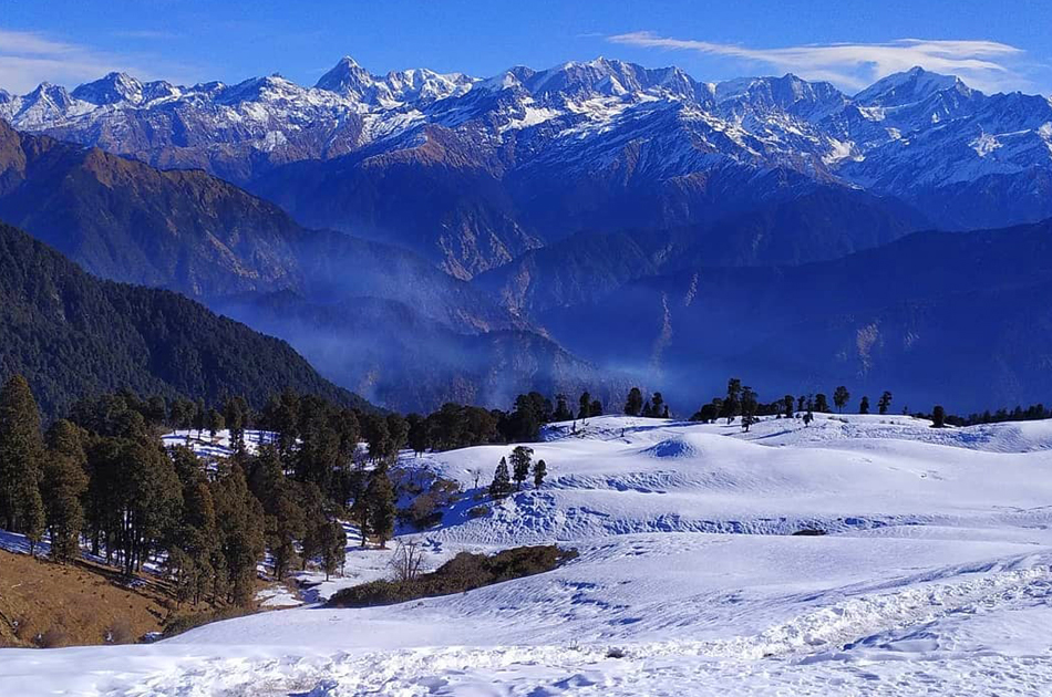
Offering the widest expanse of snowscape in Uttarakhand, Dayara Bugyal is a perfect picture of the Himalayan winters. This short trek spanning over five days remains true to its name-a Bugyal, i.e. ‘meadows’. This alpine field, that remains carpeted with wildflowers in the summer, turns into the most expansive field of snow in the winters, spread as far as your eyes can see.

With these vast open lands providing for unobstructed views of the Garhwal range, and thick forest lands blanketed by the white of freshly-fallen snow, Dayara Bugyal at an impressive altitude of 3,750M is a walk through a gallery of mountain life. The trek begins in the self-sustaining village of Raithal in the Uttarkashi district of Uttarakhand, giving you a sneak peek into the unique culture of high-altitude trekking.

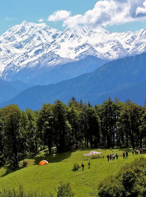
What’s even more fascinating is that this winter trek is full of surprises. The trail for this trek is simply enchanting! Lined with oak, pine and maple trees with Rhododendrons scattered across the landscape, the trails offer magnificent views of reverential peaks such as Mt. Bandarpoonch (6,316M), Mt. Srikanth (6,133 M), Gangotri I (6,672 M), and Black Peak (6,387 M). Across the summit - Dayara Top, one can witness a splendid panoramic view of the Garhwal range.

This short trek also sends you gifts in the form of two mystical high-altitude lakes- that of Gui Lake sitting idly in the midst of this frozen landscape and the seaweed-green Barnala Tal, that wears the valley’s winter colours to perfection. Adding to this beauty is the music of Russet Sparrows, Eurasian Jays and Scarlet Minivets who follow along all the way to the end of the trek.

Itinerary

The Dayara trek is reserved for participants to make their way to our homestay in Raithal in Uttarkashi. If you have signed up with us for a drive from Dehradun to Raithal, the day starts early. Please ensure you report at the meeting point by 7 AM. In case you plan to reach Raithal village In case you plan to reach Raithal village on your own, this article can come handy to plan your journey.

On our way to the basecamp, we acclimatize ourselves with the mountain climate, get comfortable around fellow trekkers, enjoy the scenic landscapes on the way which comprises of vibrant yellow mustard fields, changing shades of hilltops, the calm flow of the Bhagirathi river and the picturesque Tehri Dam Falls.

The route via Dhanaulti takes us to Chinyalisour. As we drive through these quaint towns and villages of Uttarakhand, Raithal becomes visible from a short route towards Maneri after crossing the bustling town of Uttarkashi.

After this long drive and some rest, we conduct a briefing about our schedule, know-how, basic do's and don'ts, and environmental conservation practices. As a learning based organisation, we also conduct a briefing about essentials of trekking such as a demo of how to pack one's backpacks & sleeping bags along with the briefing on arrangements of all basic equipment one may need for successful completion of the trek.

The forest permits, related paperwork and clearances are also completed on the first day so as to ensure a hassle-free trek for all of us.

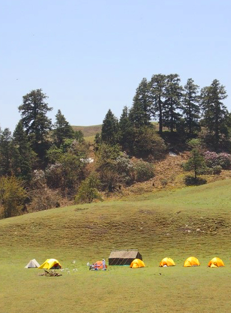
Post a filling breakfast, we begin our trek from Raithal village towards our camp in the vicinity of GUI Lake. The trail initially runs through an alley bordered by terraced farms and golden paddy fields with a local stream accompanying them.

An hour in, we deep dive into a thick forest stretch lined up with pinewood and oaks, locally called Mohru and Pangar. This continues all the way till we reach an open ground with shepherd shillings. Our campsite is not far from here. The trees form a dense cover over us, leaving us with a sense of being in the wilderness, far away from the hustle and bustle of city life. A mesmerizing view of Mt. Srikanth, Mt. Bandarpoonch and DraupadikaDaanda peaks are visible through this scenic spot.

On a good sunny day, one can see the whole panorama of Garhwal Himalayas right from Gangotri to Mt. Jaonli from these vast grounds. The elevation we gain today is about 848M.Post snacking and some rest midway, we make our way towards our campsite. Gui Campsite is just four hours away from Raithal. We reach there by early noon. We pitch our own tents with our fellow trekkers after a demo by the trek leaders.

Once the campsite is ready, we have our lunch and then get ready to visit the jade coloured Gui Lake. The winter temperatures near the lake make the water body completely frozen, even during daytimes.After spending some time around the lake and surrounding clearings,we make our way back to the campsite. The sunset views from this campsite are a highlight not to be missed! We spend the rest of the evening enjoying hot snacks followed by an early dinner.

We start the day early around 7 AM today. Morning tea followed by piping hot breakfast prepares us for the exciting day ahead. We pack our tents and start our day's trek to Chilapada. Crossing the thatch patches near Gui, we tread towards the forest patch layered with Golden Oaks and Maple trees. The trail is slightly more difficult than yesterday's, due to a steep half an hour ascent towards Chilapada campsite.

The campsite is three kilometers away from Gui Lake. Post reaching the campsite, we pitch our tents and cool off before we hike to Barnala Lake. This trail takes us through a densealpine forest and soft snowy high grounds that gradually lead to the lake.

Two seasonal, semi-frozen water bodies are visible after crossing a small boulder zone. A spellbinding view of Mt. Bandarpoonch and Gangotri peaks is visible from a spot around a dry grass thatch, just before the top, leading to the partially-frozen Barnala Lake.

Spending the afternoon around the lake and an adjoining temple, we hike back to Chilapada campsite through the woods. Evenings at Chilapada in the winters can get a bit chilly so layer up accordingly. After a hot dinner, we retire for the day to recharge ourselves for what’s to come tomorrow!

Today, we start our journey towards the highest point of the trek, i.e. Dayara Top. We begin at the break of dawn, post a sumptuous morning meal. The trail through the opaque forest patch is decorated with powdered snow uphill that leads towards the high grounds. A panoramic view of the Garhwal Himalayas presents itself to us as we reach near the last shelling or a 'Garhwali Chaani'. The snowy meadows of DayaraBugyal make an appearance from here.

Wide grounds shimmering with silver white snow can be seen in all their glory! Treading through these meadows, the panoramic view of prominent Garhwal Himalayas-Bakariya Top, Black Peak, Bandarpoonch, Mt. Srikanth, DraupadikaDaanda, Mt. Jaunli appear more alluring for their beauty and grandeur with each step forward.

The walk through the Bugyal gives way to a steeper, more upward snowy path leading to Dayara Top. Undulating, expansive snow grounds glitter with snow as far as the eye can see. The intriguing and magnanimous views from DayaraBugyal all the way up to Dayara Top are indeed worth the climb. The elevation gain today from Chilapada to Dayara Top is about 656 M.

We spend some time at the summit appreciating the spellbinding view from the top. Replenishing our energy with some snacks, we make our way back to the last shieling towards the snow section in the south west, for descent. A snow walk in a meadow with a whistling cold breeze for the next couple of hours at this elevation could prove to be a challenge, but is filled with adventure and an adrenaline rush is guaranteed.

After crossing back over the high meadows, we make our way to Nayata through oakwoods, with peeking views of Mt. Bandarpoonch and Gangotri in the background. The trail route via Barnala Tal takes us towards Nayata. A moderate descent from the lake, the 3 kms trail is lined with maple trees and dry, sparse vegetation all the way to the campsite, offering stunning views of the sun setting over the mountains. We spend the remaining time at Nayata commemorating and sharing our experiences in the company of stars before calling it a night.

We make our descent from Nayata back towards the village of Raithal today. Approximately 4 kms down through maple and oakwood trees; the forest turns moderately steep. Rhododendrons can be found aplenty on this path. We have our day’s packed lunch midway through our stride down to Raithal. The village landscape appears in the foreground from the forest, within an hour into the trail. The trail ends near GMVN cottage adjacent to a village cafe in Raithal, marking the completion of the trek. We can all now proudly say that we have completed the trek to Dayara Top - an adventure of a lifetime!

The drive back to the nearest city of Dehradun takes about 8 hours. If you have booked your trip back to Dehradun with us, we leave by 1 pm to reach the city by evening. Kindly book your accommodations and travel ahead accordingly. Should you require any assistance with the same, please feel free to get in touch. While the network coverage is minimal around Raithal village, a few points in Chilapada camp do get minimal range.

Inclusion


  • Food as per menu .Dinner on Day 1 till lunch on Day 5.
  • Forest Permits/Camping Charges, if any (upto the amount charged for Indian nationals)
  • Tents, Sleeping bags, Sleeping mats
  • Safety Equipment includes static rescue rope, seat harness, carabiners, pulleys
  • Trek guide, cook, helpers, and porters for carrying common supplies
  • Mountaineering course certified Trek Leader with Wilderness Emergency Responder & Rescue. course from NIM Uttarkashi
  • 1 night stay in Raithal in Hotel / Guest house


Exclusion


  • Portage of personal bags during the trek
  • Cost of any kind of Travel Insurance
  • Any Expense of personal nature
  • Any Expense not specified in the inclusions list
  • Meals during road journeys
  • Rucksack Offloading Optional
  • Off Roading Charges Extra


Trek With Vagabondzz